


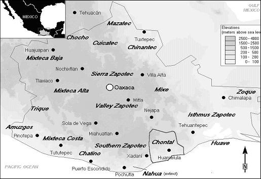
Geographic context
The Chontal region estends in the southeastern part of the Mexican state Oaxaca. It falls into the physio-geographical province of the Sierra Madre del Sur and its coastal edge, but it is divided into two geographically contrasting subregions: the highland (chontales de los altos or serranos) in the north and the narrow coastal lowlands (chontales de la baja or costeños) in the south. This division is accompanied by ecological divisions in terms of climate, soils, and vegetation, as well as socioeconomic divisions in terms of language differences and subsistence. Additionally, political administration and catholic religious administration have enhanced this twofold division from the Colonial period up to the present day.
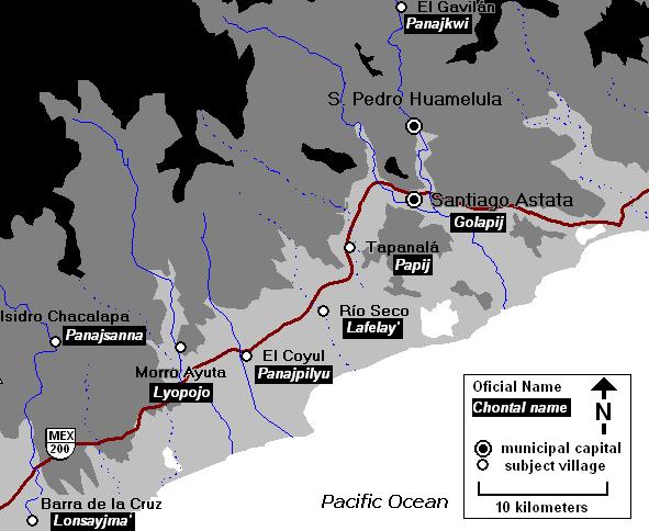
The coastal lowlands comprise the eastern Pacific stretch of the sub-province of the Costa de Sur between the Bays of Huatulco and Salina Cruz at the bay of Tehuantepec. Covering some 870 km², the coastal lowland is not an extensive littoral plain but instead comprises a series of rugged foothills and mountain ridges (50–700 m above sea level).
Geology
Most of the geological matrix in the study area consists of a metamorphic rock from the Paleozoic, which originated from sedimentary clay and sand deposits (metasedimentary rock). This rock easily erodes and produces a landscape of hills and dentritic drainages. To the south, a chain of cretaceous (Mesozoic) limestone ridges runs from west to east, producing a dramatic relief for its steep slopes and vertical cliffs. The relatively soft lime allowed the water to carve cavities of varying size into the rock. To the south of this ridge, quaternary alluvium soil covers the lower surface along the drainage channels that have meandered towards the sea further south, producing a plain of fertile soil, frequently subject to inundation. To the west and east of the Río Huamelula alluvium plain, mesomorphic rocks, identical to those in the north of the limestone barrier, emerge from the surface. At the southern extreme of the study area, there are two smaller outcrops of Precambrian Gneiss, surrounded by the alluvium plain. The littoral sand beach is interrupted by rocky outcrops that frequently reach the shore.
Topography
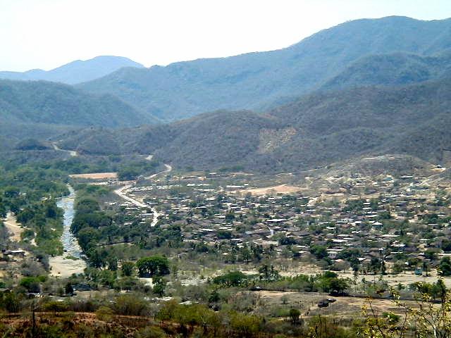
The topographic relief of the study area is characterized by a prominent west-east running limestone ridge, and the narrow Río Huamelula river valley perpendicularly cutting through this ridge from the north. At Cerro El Boquerón, the limestone ridge reaches its highest elevations at about 720 m above sea level. The surrounding extensive zone of foothills, whose height oscillates between 200 m and 300 m above sea level, increases toward the north, where it forms the piedmont of the Sierra Madre del Sur mountains. Most of the foot hill slopes are moderate except at the eastern side of the Río Huamelula, where they are too steep to be occupied. Hilltop surfaces are rather small.
Hydrography
The Río Copalita and the Bay of Salina Cruz define the western and eastern extremes of the coastal Chontal region. In between, five river valleys cut through the coastal foothills; from west to east they are the Río Zimatán, Río Chacalapa, Río Ayuta, Río Huamelula, and Río Tenango. These rivers run from the northern mountains to the Pacific Ocean in the south for up to 30 km. Water levels fluctuate heavily according to the twofold division of rain and dry season. Some of them only carry water during summer and fall. Two rivers define the basic hydraulic situation of the study area. The Río Huamelula flows throughout the year, although water level and velocity depend on the annual rhythm of the dry and rainy seasons. The Río Huamelula runs from north to southeast through a narrow channel, producing only a few fertile alluvial pockets. During the rainy season, smaller arroyos carry water between the foothills to the Río Huamelula, the most important ones being called La Powa, Mishi, Lowí, and Panahueyhué. Only after passing the limestone barrier of El Boquerón does the Río Huamelula have enough space to deposit a more extensive alluvial plain. South of the village of Santiago Astata, the Río Huamelula is fed by the seasonal waters of Río Santa Maria which flows in the rainy season through a neighboring river valley to the west. The village of Santiago Astata lies at a low altitude right next to the joint of the two rivers of Río Huamelula and Río Santa María. The floods accompanying hurricane Paulina in 1997 severely damaged parts of Astata. A lagoon of saltwater is situated right west of Piedras Negras, at the southwestern extreme of the study area. The Laguna Grande was frequently visited for salt extraction and fishing, but at present, both activities are being abandoned here in favor of other lagoons.
Soils, vegetation, and agricultural use
The two principal components of the surface in the study area largely define the agricultural productivity and use: the hilly region with a dense overgrowth of low caduceus trees, thorny shrubs, and weeds dominates the entire study area. It is interrupted only by the flood plain, which is either cultivated or grazed by cattle. North of the limestone barrier, the soil of the foot hill slopes is thin and heavily affected by pluvial erosion. Shrubs and weeds are the dominant vegetation on the hills and slopes if a portion is left fallow. In some higher elevations, some trees are suitable for lumber, but such wood is increasingly disappearing. Milpas, i.e. slash-and-burn fields, extend over these slopes to cultivate maize, which is the dominant crop. Even the steeper hill slopes are used for milpa cultivation, but without any terracing. Irrigation is only occasionally employed and some milpas close to the river bed are fed with deviated river water.
The higher elevations are said to be suitable for maguey cultivation, while sugar cane was recently planted close to the Río Huamelula. The community of Huamelula entertains a communal field, “El Pushi,” about one kilometer south of the village, on a fertile alluvial pocket next to the Río Huamelula. This terrain receives artificial irrigation and regular attention through tequio labor, thus producing rich harvests of coconuts, maize, and other vegetation. Apart from the fertile field of El Pushi, most of this unfavorable land is distributed in small private lots. The ejido system, as well as Bienes Comunales, the communal institution for administrating the lands, is out of function in Huamelula. In the municipality of Astata, this situation is markedly different. Astata holds most of the fertile alluvial plain south of the limestone ridge. Most of the ejido system from the early twentieth century is still functioning, which has resulted in a large proportion of land belonging to the community instead of private owners. The extensive fields on the flood plain are annually cultivated with maize, sesame (ajonjoli) and peanuts, and there is enough space to herd some cattle. The thin and fragmented littoral yields the typical coastal dune vegetation.
Climate
The entire region is described as tropically hot and sub-humid (Awg according to the classification of Köppen. There is a marked difference between the dry season between October and May and the rainy season from June to September. Average annual temperature is between 20 and 25 degrees Celsius. This climate determines a distinct differentiation in the vegetation cycle, during which the caduceus plants turn from a lush green into a dusty brown-gray during the dry season. The dense summer overgrowth of fallow areas makes effective field-walking for survey virtually impossible. Most of the agricultural productivity is therefore restricted to seasonal growth, and harvests are usually in the fall after the rainy season. If sufficient rain does not fall early enough in June, the sowing of maize may start too late to harvest fully grown cobs. Hurricanes can have catastrophic dimensions in the study area, as the hurricane Paulina showed in 1997, changing the course of water streams, the shore line, and destroying many of the flimsy dwellings.