

The Taa settlement area includes parts of the Kgalagadi and Ghanzi districts in Botswana and of the Omaheke and Hardap regions in Namibia. It is part of the southern Kalahari sandveld covered by Acacia shrublands. Annual rainfall amounts to about 200-350 mm per annum and decreases from north to south with rains occurring mainly in summer. In the rainy season water accumulates in pans. Differences in altitude are slight and usually do not exceed more than ten meters from the bottom of a pan to the top of a dune.
The most characteristic landform of the southern Kalahari is a pan (n!au-sa’an) with an associated lunette dune (!uhm) on its leeward southern or south-eastern rim. Pans and dunes were crucial for orientation and the focal points of foraging areas. The actual waterhole with clayey ground and without vegetation (!xubi) is surrounded by the flat interior of the pan covered by grass and herbs (n!au-sue) which in turn is surrounded by the slightly elevated sides characterized by loose stones and bush vegetation (||xari), finally merging into the dune (!uhm) with a backward slope (!oa) and the overall sandy plain with trees (g!qoqma) which may be followed by another pan (n!au-sa’an) or a pan in nascent stage (!”ari).
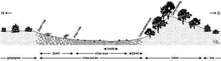
Taa model of the southern Kalahari landscape
Source: Boden, Gertrud. 2009. From Utility to Perceptual Salience: Cultural, Lexical, and Conceptual Change in the Southern Kalahari Landscape. Anthropological Linguistics, Volume 51, Numbers 3-4 pp. 303-27. DOI: 10.1353/anl.2009.0006
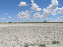
Waterhole (!xubi) in dry season
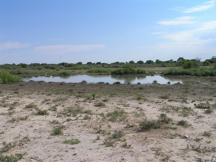
Waterhole (!xubi) in rainy season
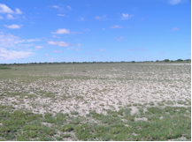
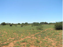
Pan interior (n!au-sue)
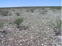
Stony area (||xari)
Dune top (!uhm n|ang)
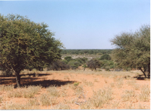
Sandy plain with trees (g!qoqma)