

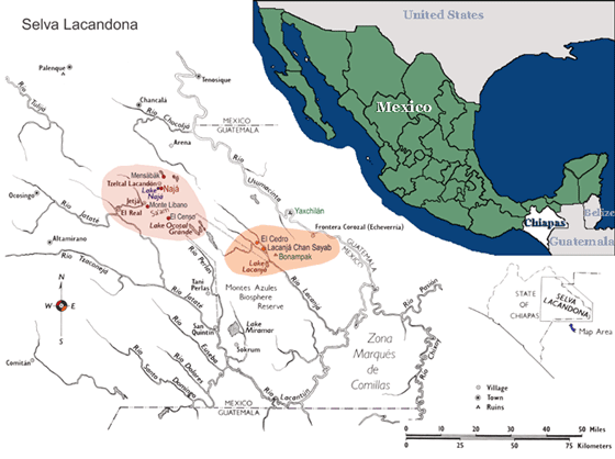
The population constitutes two main groups that are named according to their geographic location: The northern Lacandones are located northeast of the Usumacinta River. The southern Lacandones reside southeast of the northern Lacandón territory, close to the Maya ruins of Bonampak.
Rivers
Principally, Usumacinta, Lacantún, and Lacanhá, the latter two join with the Chixoy (or Salinas) (Tozzer 1907:14). Other rivers in the area are the Jatate, La Pasión, Tzendales, and Grijalva (Boremanse 1998). Blom and Blom(1969:276) observed that the northern Lacandón were spread over the territory between the Rio Santa Domingo and the Rio Santa Cruz and north of the Arroyo Jetha.
Mountains
The state of Chiapas is mountainous with two distinct regions. One half is composed of a chain of mountains and the other of a mountain mass (Tozzer 1907:16. See Sapper 1897:178).
The northern Lacandon community of Naha is the focus of this documenation. It is situated at the following location:
Altitude: 400 – 1500 metres. Naha is approximately 600 meters high
Longitude: Between 92 degree 00 minutes and 91 degrees 45 minutes
Latitude: 17 degrees 00 minutes